Mitigating flood risk – Rain water management

PDP_Rain Water Management

In a natural landscape, rain water is naturally absorbed and soaked into the ground, feeding water streams and rivers, supporting trees and vegetation as well as regulating ambient temperature by surface evaporation.

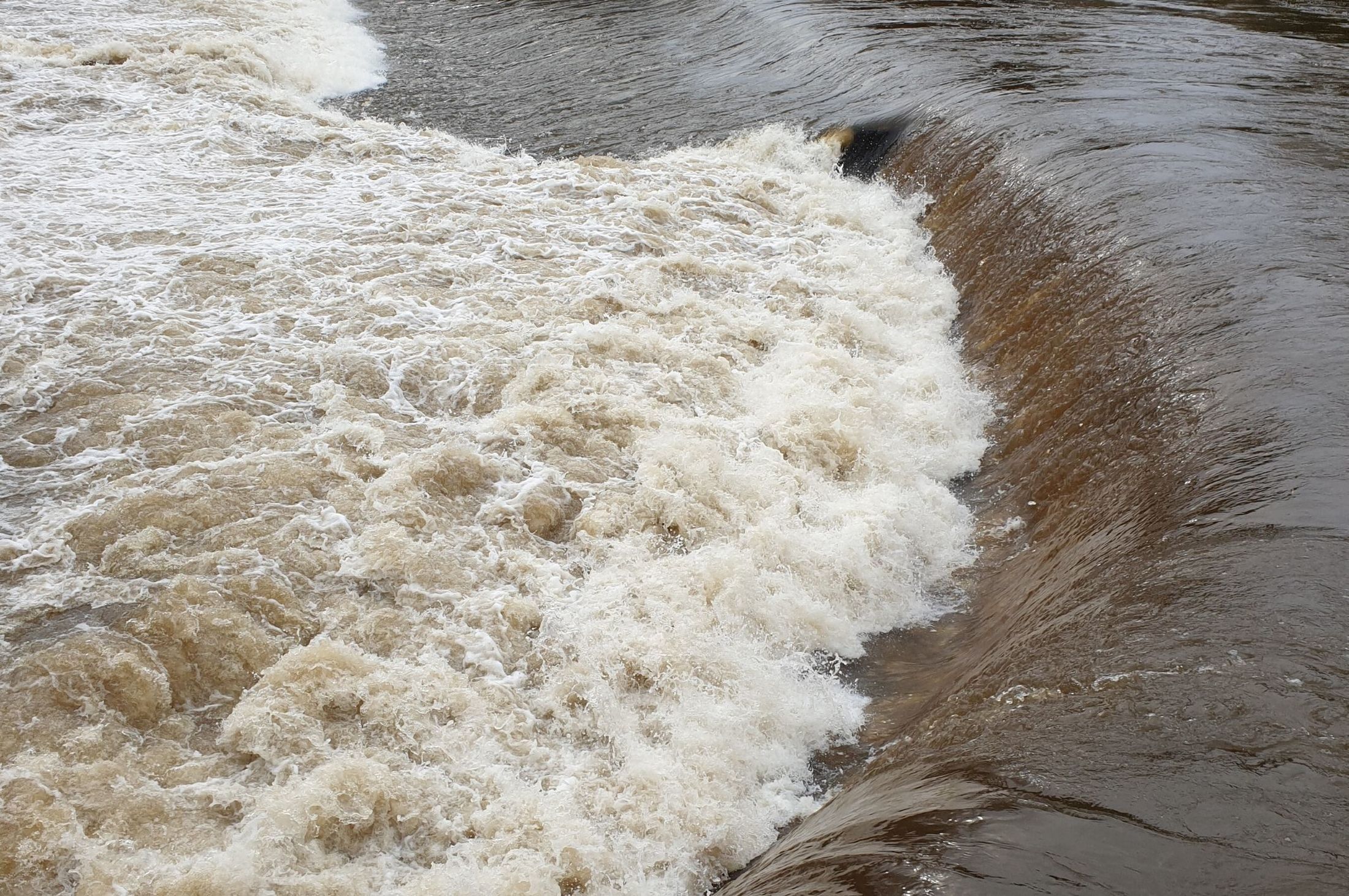
Construction and developments alter the water cycle, changing how, when and more importantly where our rain goes by increasing surface runoff and washing off pollution from our roads and hard surfaces. As the flow of water increases and drainage capacity is compromised, the risk of flooding is also higher. Permeable surfaces help to slow down water flow allowing watercourses to deal with excess water better decreasing the risk of flooding with the added benefit of proving better water quality to our watercourses.

Permeable surface can include:

  • Permeable paving
  • Rain gardens
  • Green roofs
  • Tree pits
  • Swales
  • Bio retention areas
  • Wet basins and Ponds
  • Dry basins
  • Wetlands
  • Underground water storage

Using permeable surfaces allow rainfall to soak into the ground, rills, channels and bio retention areas slow the flow, treat the water and store the rain. Vegetation also increases surface water runoff capture, providing biodiversity and ecology networks.

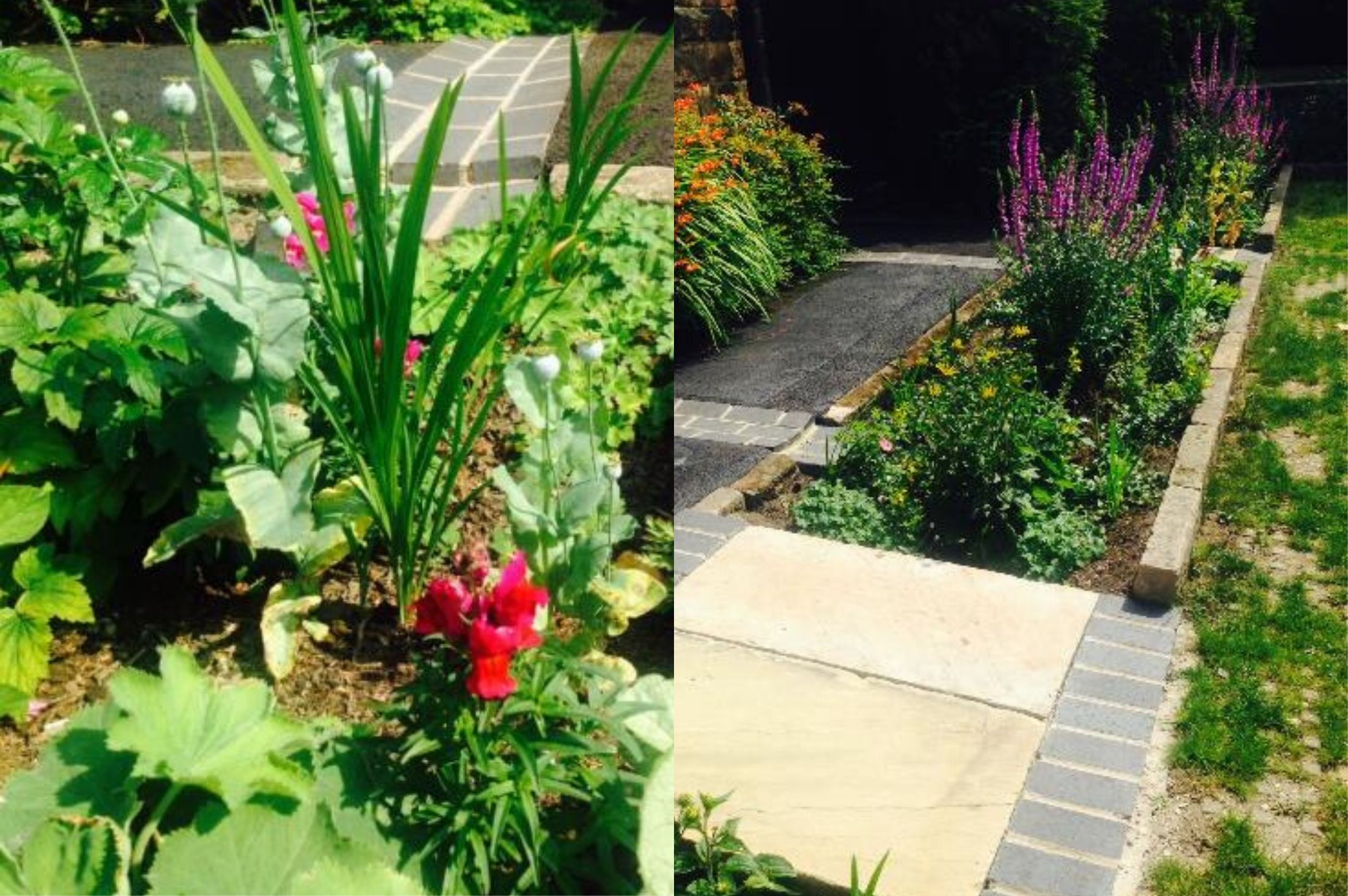
All of the above can be integrated into any project providing a great opportunity for the creation of great spaces for the community that are resilient and are able to adapt to a changing and challenging climate. A good example of this is the Strutts Centre and their Rain Garden retrofit project in Belper, which has no doubt helped to improve the local environment.

As we come to the spring and summer, if you are a keen gardener like me, you will be used to hearing about hosepipe bans and water restrictions in parts of the UK. A topic perhaps less discussed around here, is water demand in our developed environment. Just to bring an example from across the pond, in the western USA in years of normal rain fall, landscape irrigation can account for up to 43% of all residential water use, and perhaps closer to the UK, up to 26% in the wetter eastern USA.

Perhaps we all, architects, planners, designers, gardeners, citizens in general should open our eyes to a better water management approach from the outset on every project, however small they are and as simple and common as a new driveway.

Fernando Collado Lopez, Architect, Planning & Design

Top Images: With thanks to the Strutts Centre – Brick rain channel and linear rain garden in front of the old caretaker’s house.

Recent Flooding

PDP_Recent Flooding

Recent heavy rainfall resulted in numerous flood alerts being issued across Derbyshire, and South Yorkshire and the weekend saw the River Derwent burst its banks, with the resultant flooding causing travel chaos, widespread disruption and a tragic loss of life.

Derbyshire was hit with more rainfall in 24 hours than it normally receives in a month. The Environment Agency’s gauge in Glossop, a market town on the edge of the Peak District, recorded 114mm of rain in the 24 hours up to 4am. On average Derbyshire receives 90.7mm of rain during the month of November.

This is just months after the evacuation of the Derbyshire town of Whaley Bridge, when thousands of residents were evacuated amid fears a dam could collapse after being damaged by floodwaters.

Heavy rainfall saw concrete panels on one side of the dam on the Toddbrook Resevoir, which holds 300 million gallons of water, partially collapse, creating a crisis that has cost Derbyshire County Council in the region of £700,000.

At the height of the situation, a Chinook helicopter from RAF Odiham, was engaged for a combined 72 hours over several days to drop more than 600 tonnes of aggregate on the damaged dam to prevent it breaching.

In a report published in May 2018, the Royal Institute of British Architects (RIBA) state that the government needs to do to help create homes and communities that are resilient to flood damage. In the report, titled “The Value of Flood Resilient Architecture and Design” RIBA stresses that the UK can no longer base its approach to managing flood risk on simply keeping the water out, and highlights the following statistics:

  • Currently 1 in 6 homes in the UK are at risk of flooding – a number that is expected to double by 2050
  • Flooding causes an average of £1.4 billion of damage each year to businesses and households

Meanwhile a new report from the Royal Town Planners Institute (RTPI) has said that sustainable drainage systems (SuDS) are not being delivered at either the pace or scale that is required to cope with the challenges posed by climate change.

The systems are considered an important way of managing surface water runoff in built developments. National planning policy has encouraged their use in all major developments since their introduction into the English planning system in 2010.

However, 96% of local authorities report that the quality of planning submissions for SuDS are either ‘inadequate’ or ‘mixed’. Furthermore, 25% of local authorities have no formal SuDS policies in place, nor any immediate plans to implement any.

According to officials at Derby Council, closing the flood gates at Haslam’s Lane and Darley Fields for the first time saved around 1,140 homes from flooding in the Chester Green and Darley areas during the recent deluge. The gates are part of the city’s £95 million flood defences – part of which are still under construction.

Whilst the successful implementation of the flood defences offers reassurance, with more heavy rainfall forecast, the Council, together with home, business and landowners will be anxiously watching the weather forecasts as we head into the winter months.

“As the effects of climate change become even more apparent new development must become more robust. Land use has a big part to play. The flood allowance for climate change has increased over the past 10 years and the Environment Agency is looking to raise the figure further said Jonathan Jenkin, Managing Director of Planning & Design.

“As one in one hundred year flood events become common place, locations which we thought would not flood are now flooding. This means that we must have effective surface water run-off measures in place to hold surface water in new developments to prevent run-off adding to flooding elsewhere.

As planners we should avoid building vulnerable developments on floodplains such as housing but in some locations whole towns are liable to flooding. In locations such as this house building needs to take into account flood risk and be built to allow for and accept flooding.

For the government, the wider strategy for climate change resilience must include changes to land use including reforestation of the uplands, retrofit and new build development to zero carbon, a major shift from car use to public transport and a national policy for flood protection, with a national debate over the costs and the benefits of maintaining settlements and communities liable to regular flooding by rivers and near to the sea.”

GET IN TOUCH